Maritiem Digitaal
collectie zoeksyteem van de maritieme musea
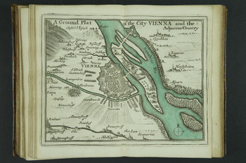
A Ground Plat of the City VIENNA and the Adjecent Country


| titel | A Ground Plat of the City VIENNA and the Adjecent Country |
|---|---|
| inventarisnummer | BWAE150-P18 |
| collectie | cartografie |
| museum | Maritiem Museum Rotterdam
|
| maker | Seller, John |
| omschrijving | Kaart opgenomen in de uitgave A New Systeme: of Geography, Designed in a Most Plain and Easy Method, for the better Understanding of that Science. Accommodated With New Mapps, of all the Countreys, Regions, Empires, Monarchies, Kingdoms, Principalities, Dukedoms, Marquesates, Dominions, Estates, Republiques, Soveraignties, Governments, Seignories, Provinces, and Countreys in the whole World. With Geographical Tables, Explaining the Divisions in Each Mapp. / by John Seller, Hydrographer to the King. Stadskaart van Wenen langs de rivier de Donau. De rivier is blauw/groen ingekleurd en genaamd ‘Danubius Flu’ = rivier Donau. De omringende dorpen/steden zijn afgebeeld met naam. |
| afmetingen | hoogte 12 cm breedte 15.5 cm hoogte 14.5 cm breedte 19.5 cm |
| startdatum | 1650 |
| einddatum | 1650 |
Bekijk ook

website: Trilobiet ID


Commentaar van bezoekers