Maritiem Digitaal
collectie zoeksyteem van de maritieme musea
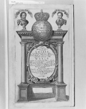
ATLAS MARITIMUS or a book of charts. Describeing the SEA Coasts Capes Headlands Sands Shoals Rocks and Dangers. the Baye...


| titel | ATLAS MARITIMUS or a book of charts. Describeing the SEA Coasts Capes Headlands Sands Shoals Rocks and Dangers. the Bayes Roads Harbors Rivers and Ports. in most of the knowne parts of the World. With the true Courses and distances, from one place to another, Gathered from the latest and best Discoveryes, that have bin made by divers Able and Experienced Navigators, of our English Nation, Accomodated with an Hydrographicall / Description of the whole WORLD. / By John Seller. Hidrographer to y.e Kings most Excellent Majestie And are to be Sold by him, at the Hermitage Staires in Wapping, and at his Shop in Exchange Alley. Near the Royall Exchange. in London. Cum Privilegio. |
|---|---|
| inventarisnummer | WAE114 |
| collectie | cartografie |
| museum | Maritiem Museum Rotterdam
|
| maker | Seller, John; Colson, John; Darby, John; Fisher, William; Thornton, John |
| omschrijving | Wereldkaart en wereldzeeën, 1 deel in 1 band, 45 kaarten, gekleurd. Ontbreekt: k(9), (12), (17), (26), (31), (32), (42), (43, (44), (46) en (49). Toegevoegd: tweede exemplaar van k(10), (11), (13), (34), (39), (40), (47); volgens Phillips 4153 k(3) twee exemplaren, (51) en 1. A chart of the sea-coasts of the South part of America ... by John Seller, at the Hermitage in Wapping. 2. A chart of England, Scotland and Ireland with the Channell. By John Thornton, Iohn Seller, Willim Fisher, James Atkinson, Iohn Colson. Volgens Verner is de titelpagina te dateren op 1678. (Atlas maritimus, state 1, titelpagina zuilen en globe, 2de staat). Voorin een handgeschreven index en een ex-libris van de Gaddesden Library (Engeland) |
| afmetingen | hoogte 45.5 cm breedte 30.0 cm |
| startdatum | 1675 |
| einddatum | 1675 |
Bekijk ook

website: Trilobiet ID


Commentaar van bezoekers