| 1 |
Flaggen aller seefahrenden Nationen. |  | 
Fries Scheepvaartmuseum | |
| 2 | 1993.2030
The seaman's new guide and coaster's companion | | 
Het Scheepvaartmuseum | |
| 3 | 1993.3351
Sailing directions for the East Coast of England, from London to Dungeness, Flamborough Head and Newcastle including the River Thames, Harwich, Orfordness, Yarmouth Roads, Lynn, and Boston Deeps, and the River Humber, also Yarmouth and Hasborough Sands, Smith's Knoll, Leman and Ower, Dudgeon Shoal, ... | |
Het Scheepvaartmuseum | |
| 4 | 1998.3105
Kaart van de Indische Oceaan en een gedeelte van de Stille Oceaan door J.S. Hobbs. [...] |  |
Het Scheepvaartmuseum | |
| 5 | 1998.3107
Zeekaart van de Zuid-Atlantische Oceaan, door J.S. Hobbs FRGS. [...] | |
Het Scheepvaartmuseum | |
| 6 | 8363
Three hundred and six illustrations of the maritime flags of all nations : arranged geographically, with enlarged standards ... | | 
Maritiem Museum Rotterdam | |
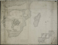
| 7 | A.0780(08)
Kaart van het noordwestelijk deel van de Atlantische Oceaan naar Engelse | |
Het Scheepvaartmuseum | |
| 8 | A.0780(09)
Kaart van de Noord-Atlantische Oceaan, door J.S. Hobbs. | |
Het Scheepvaartmuseum | |
| 9 | A.0780(10)
Kaart van de Zuid-Atlantische Oceaan, door J.S. Hobbs. | |
Het Scheepvaartmuseum | |
| 10 | A/007/048
Wereldzeekaart J.S. Hobbs, 1874'A general chart for the purpose of pricking off a ship's track from England & c., southward and round the world', 1874 | | 
Marinemuseum Den Helder | |
| 11 | A/007/156
Zeekaart van de wereld (1864) van KTZ C. Vreede (1845-1911) | |
Marinemuseum Den Helder | |
| 12 | K1325
England and Holland, &c. From Beachy Head to the River Humber, and from Boulogne to the Texel. | |
Maritiem Museum Rotterdam | |
| 13 | K1326
England and Holland, &c. From Beachy Head to the River Humber, and from Boulogne to the Texel. | |
Maritiem Museum Rotterdam | |
| 14 | K1332
A Chart of St.-George's and Bristol Channels, with plans of Liverpool, Holyhead, Carlingford, Ardglass, Larne, Campbellton, The Clyde & Lamlash | |
Maritiem Museum Rotterdam | |
| 15 | K1333
St. George's Channel | |
Maritiem Museum Rotterdam | |
| 16 | K1339
A chart of the coasts of Batavia and Germany, from the Texel to the river Hever including the rivers Ems, Jade, Weser, Elbe & Eider. | |
Maritiem Museum Rotterdam | |
| 17 | K1359
South Atlantic Ocean | |
Maritiem Museum Rotterdam | |
| 18 | K1363
Coast of the Cape Colony, Delagoa Bay & c., Madagascar, Bourbon, Mauritius &c. | |
Maritiem Museum Rotterdam | |
| 19 | K1378
A chart showing the navigation through the Strait of Malacca, to Singapore, &c. | |
Maritiem Museum Rotterdam | |
| 20 | K5566
Chart of the Black Sea with the Seas of Marmara and Azow drawn from the French, Russian and English Surveys [...] | |
Maritiem Museum Rotterdam | |