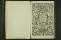
| 1 | B4988-P01-TP
Titelpagina van 'Iohn Huighen van Linschoten...' |  | 
Maritiem Museum Rotterdam | |
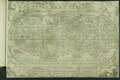
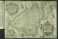
| 2 | B4988-P02
Kaart van de wereldTypus Orbis Terrarum | |
Maritiem Museum Rotterdam | |
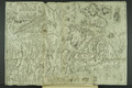
| 3 | B4988-P03
Kaart van MadagaskarI.S. Laurentij. | |
Maritiem Museum Rotterdam | |
| 4 | B4988-P04
Kaart van Ilha de Moçambique, gelegen in een baai in de straat van MozambiqueThe discription of the Islandes and Castle of Mozambique, lyeinge uppon the borders of Melinde, rich of Eban wood, fine Goulde, and Ambergrize, frowhence many Slaves are caried into India. | |
Maritiem Museum Rotterdam | |
| 5 | B4988-P05
Kaart van de noordellijke deel van de Indische OceaanThe description of the coast of Abex, The straights of Meca, otherwise called the Red Sea, the coastes of Arabia, Ormus, and Persia, to the River of Sinde of the River Indus, of Cambaia, India, and Malabar, The Ilands of Ceilon, Choramandel, and O... | |
Maritiem Museum Rotterdam | |
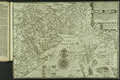
| 6 | B4988-P06
Kaart van het westelijke deel van de Indische OceaanThe description or Caerd of the Coastes of the Countreys following called Terra do Natal, all the Coast of Sofalae, Mozambique, Melinde, and the Iland of Saint Laurence, with all their Hands, Cliffes, Drougthes, and Shallowes, allso the Ilandes of ... | |
Maritiem Museum Rotterdam | |
| 7 | B4988-P07
Kaart van SumatraSumatra Insula | |
Maritiem Museum Rotterdam | |
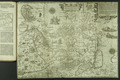
| 8 | B4988-P08
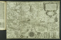
Kaart van de Indische Archipel,Oost-Azië en Zuidoost-Azië.The trew description of all the Coasts of China, Cauchinchina, Camboya, Syao, Malaca, Arraacan, and Pegu, together with all the Illands there abowts, both grent and smale, with the Cliffes, Breathes, Sands, Droughts and Shallowes, all perfect... | |
Maritiem Museum Rotterdam | |
| 9 | B4988-P09
Kaart van JavaIava Maior | |
Maritiem Museum Rotterdam | |
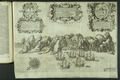
| 10 | B4988-P10
Kustprofiel van Sint-HelenaThe Island of St Helena full of Sweet and pleasaunt ayre fruitfull groundand fresh water, but not inhabited: a good refreshing for those yt come out of east India it lyeth under 16. degrees on the south syde of the equinoctiall lyne. | |
Maritiem Museum Rotterdam | |
| 11 | B4988-P11
Kaart van de kustprofielen van Sint-HelenaThe true description, and scituation of the Island St Helena, on the East, North, and West sydes, lying under 16 degrees on the Southsyde of the Equinoxiall line. | |
Maritiem Museum Rotterdam | |
| 12 | B4988-P12
Kaart van Sint-HelenaSancta Helena | |
Maritiem Museum Rotterdam | |
| 13 | B4988-P13
Kaart van het eiland AscensionThe trus Description of the Island of Ascention lying under 8 degrees on ye South syde of the Equinoctiall lyne. | |
Maritiem Museum Rotterdam | |
| 14 | B4988-P14
Kaart van de westkust van Afrika en het midden van de Atlantische OceaanThe description of the Coast of Guinea, Manicongo, and Angola, and so proceeding forwards beyond the Cape Bona Speranze ... | |
Maritiem Museum Rotterdam | |
| 15 | B4988-P15
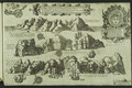
Kaart van AfrikaA discripsion of Aegipt from Cair downeward | |
Maritiem Museum Rotterdam | |
| 16 | B4988-P16
Kaart van CongoThe Kingedome of Congo | |
Maritiem Museum Rotterdam | |
| 17 | B4988-P17
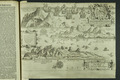
Kaart van Zuid-AmerikaThe description of the whole coast lying in the South seas of Americae calles Peru ... | |
Maritiem Museum Rotterdam | |
| 18 | B4988-P18
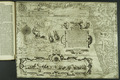
Kaart van de wereldIehova | |
Maritiem Museum Rotterdam | |
| 19 | B4988-P19
Kaart van de Indonesische archipel, de Filipijnen en omliggende regio'sInsulae Moluccae celeberrimae sunt ob Maximam aromatum copian quam per totum terarum orbem mittunt ... | |
Maritiem Museum Rotterdam | |
| 20 | B4988-P20
Kaart van SpanjeHispania | |
Maritiem Museum Rotterdam | |