| 1 |
The sea-gunner |  | 
Maritiem Museum Rotterdam | |
| 2 |
The English pilot | |
Maritiem Museum Rotterdam | |
| 3 | 29049
A New Systeme: of Geography, Designed in a Most Plain and Easy Method, for the better Understanding of that Science. Accommodated With New Mapps, of all the Countreys, Regions, Empires, Monarchies, Kingdoms, Principalities, Dukedoms, Marquesates, Dominions, Estates, Republiques, Soveraignties, Gove... | |
Maritiem Museum Rotterdam | |
| 4 | 29278
A Pocket Book Containing severall Choice Collections in Arithmetick. Navigation. Astronomy. Astrology. Geometry. Geography. Surveying. Measuring. Dialling. Gageing. | |
Maritiem Museum Rotterdam | |
| 5 | 29285
Practical Navigation or, an Introduction to the Whole Art. Containing many useful Geometrical Definitions and Problems; The Doctrine of Plain and Spherical Triangles; Plain Mercator, and Great-Circle-Sailing; Sundry useful Problems in Astronomy; The use of Instruments; The Azimuth-Compass; Ring-Dial... | |
Maritiem Museum Rotterdam | |
| 6 | 30328
Practical Navigation or, an Introduction to the Whole Art. Containing many useful Geometrical Definitions and Problems; The Doctrine of Plain and Spherical Triangles; Plain Mercator, and Great-Circle-Sailing; Sundry useful Problems in Astronomy; The use of Instruments; The Azimuth-Compass; Ring-Dial... | |
Maritiem Museum Rotterdam | |
| 7 | A.1516
The coasting pilot; describing the sea-coasts, channels ... and sea-marks, upon the coasts of England, Flanders and Holland; with directions to bring a shipp into any harbour ...; being furnished with new draughts, charts and descriptions, gathered from the expérience and practise of diverse able an... | | 
Het Scheepvaartmuseum | |
| 8 | A.2150(06)
Atlas maritimes or the sea-atlas; being a book of maritime charts; describing the sea-coasts of the world ... | |
Het Scheepvaartmuseum | |
| 9 | BWAE150-P01
A New Systeme: of Geography. Reduced to a Most Plain & Easy Method. For the Ready finding out any Empire, Kingdom, Principality or Government in ye whole World. |  |
Maritiem Museum Rotterdam | |
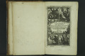
| 10 | BWAE150-P02-TP
Titelpagina | |
Maritiem Museum Rotterdam | |
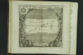
| 11 | BWAE150-P03
A Mapp of the five zones | |
Maritiem Museum Rotterdam | |
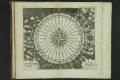
| 12 | BWAE150-P04
Pixis Nautica of the Marriners Compas Showing the Names of the Points | |
Maritiem Museum Rotterdam | |
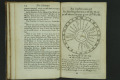
| 13 | BWAE150-P05
An Instrument for finding the hour of the Day (at all times) in any part of ye World. | |
Maritiem Museum Rotterdam | |
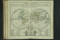
| 14 | BWAE150-P06
A Mapp of the World. Showing what a Clock it is (at any time) in any part of the World. And to know where the People are Rising, and where they are at Dinner, where at Supper, and where going to Bed all over the World. | |
Maritiem Museum Rotterdam | |
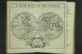
| 15 | BWAE150-P07
A NEW MAPP OF THE WORLD | |
Maritiem Museum Rotterdam | |
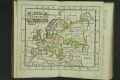
| 16 | BWAE150-P08
Europe | |
Maritiem Museum Rotterdam | |
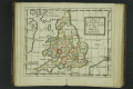
| 17 | BWAE150-P09
A Mapp of the Kingdom of ENGLAND and WALES | |
Maritiem Museum Rotterdam | |
| 18 | BWAE150-P10
Scotland | |
Maritiem Museum Rotterdam | |
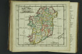
| 19 | BWAE150-P11
Ireland | |
Maritiem Museum Rotterdam | |
| 20 | BWAE150-P12
The XVII Provinces | |
Maritiem Museum Rotterdam | |