Maritiem Digitaal
collectie zoeksyteem van de maritieme musea
zoekresultaten
zoekvraag: maker = Heather, William
aantal treffers: 7
| titel | type | museum | afbeelding |
|---|
| 1 | 1994.0236
The New British Channel pilot : containing sailing directions from London and Yarmouth to Liverpool, and from Calais to Brest : also for The Coast of Ireland, from Dublin to Galway Bay ... |  | 
Het Scheepvaartmuseum | |
| 2 | B.0216(0246)
The new North Sea Pilot containing sailing directions from the Nore to the Shetland Islands and from Calais to the Scaw ; also for the Coast of Norway to Cristiana : describing the capes, headlands, bays, roads, harbours, rivers, rocks, sands, shoals, depths of water, light houses &c ... | |
Het Scheepvaartmuseum | |
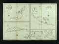
| 3 | K226
The Island of Curacao by W. Heather. 1808. Stephenson Engraver. The Island of Bcouya ... The Island of Rattan ... The Harbor of New Port Royal In ... Rattan. The bay of St. Anns in Curacao |  | 
Maritiem Museum Rotterdam | |
| 4 | S.0521(118)
Zeekaart van de Golf van Biscaije door John William Norie (1722-1843), verbeterd naar Tofino de San Miguel (ca. [...] | |
Het Scheepvaartmuseum | |
| 5 | S.0521(128)
Zeekaart van de Kaap Verdische Eilanden, in 1805 door John William Norie (1722 - 1843), gravure J. Stephenson, uitgave William Heather, Londen, 1814. [...] | |
Het Scheepvaartmuseum | |
| 6 | S.1604(01)
Zeekaart van Het Kanaal | |
Het Scheepvaartmuseum | |
| 7 | S.1769(14)
Zeekaart van het St George's Kanaal, door John William Norie (1722 - 1843). [...] | |
Het Scheepvaartmuseum | |