Maritiem Digitaal
collectie zoeksyteem van de maritieme musea
zoekresultaten
zoekvraag: maker = Faden, William
aantal treffers: 10
| titel | type | museum | afbeelding |
|---|
| 1 |
Catalogue of the geographical works, maps, plans etc. published by W. Faden, 5, Charing Cross, Geographer to His Majesty |  | 
Maritiem Museum Rotterdam | |
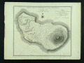
| 2 | K102
The Island of St Eustatius corruptly St Eustatia |  |
Maritiem Museum Rotterdam | |
| 3 | K1469
A new map of the Colony of Surinam, in Guiana; South America. Describing, all the Rivers and Districts, as far as the same have been discovered ; likewise the cultivation of the lands and plantations, surveyed By order of the States of the Colony, 1784. | |
Maritiem Museum Rotterdam | |
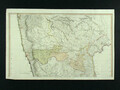
| 4 | K212-1
A Map of the Peninsula of India from the 19th degree north latitude to cape Comorin. MDCCXCII. London Printed for W. Faden ... 1795. second edition. | |
Maritiem Museum Rotterdam | |
| 5 | K212-2
A Map of the Peninsula of India from the 19th degree north latitude to cape Comorin. MDCCXCII. London Printed for W. Faden ... 1795. second edition. | |
Maritiem Museum Rotterdam | |
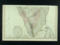
| 6 | S.0521(125) [nr 0001]
Kaart van het eiland Madeira en de Dezertas en Porto Santo Eilanden opgenomen in 1788 door William Johnston, opgedragen aan John Henry graaf Wycombe. [...] | | 
Het Scheepvaartmuseum | |
| 7 | S.0521(125) [nr 0002]
'Plan of the Road of Funchal.' Plankaart van rede van Funchal en aanzicht en het eiland Madeira [...] | |
Het Scheepvaartmuseum | |
| 8 | S.3496(23)
Kaart van een gedeelte van de Noordzee door lt. [...] | |
Het Scheepvaartmuseum | |
| 9 | S.3496(24)
Kaart van het oostelijk deel van de Noordzee | |
Het Scheepvaartmuseum | |
| 10 | WAE695-A
Colombia Prima or South America in which it has been attempted to delineate the extent of our knowledge of that Continent. Extracted chiefly from the original manuscript maps of His Excellency the late Chevalier Pinto; likewise from those of João Joaquim da Rocha, João da Costa Ferreira; El Padre Fr... | |
Maritiem Museum Rotterdam | |